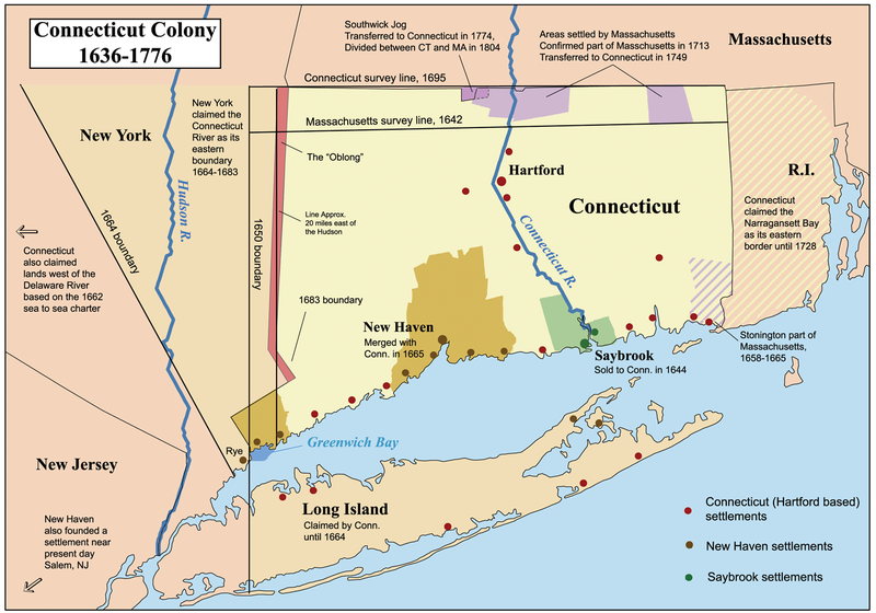
Fil:Ctcolony.png

Størrelse på denne forhåndsvisningen: 800 × 560 piksler. Andre oppløsninger: 320 × 224 piksler | 640 × 448 piksler | 1 024 × 717 piksler | 1 428 × 1 000 piksler.
Opprinnelig fil (1 428 × 1 000 piksler, filstørrelse: 817 KB, MIME-type: image/png)
Filhistorikk
Klikk på et tidspunkt for å vise filen slik den var på det tidspunktet.
| Dato/klokkeslett | Miniatyrbilde | Dimensjoner | Bruker | Kommentar | |
|---|---|---|---|---|---|
| nåværende | 2. jun. 2014 kl. 05:06 |  | 1 428 × 1 000 (817 KB) | JeffyP | I'm here to make the world a little bit smaller ☺ |
| 10. jan. 2008 kl. 20:19 |  | 1 428 × 1 000 (909 KB) | Kmusser | Major revision to include disputes with Massachusetts and Rhode Island. | |
| 12. okt. 2006 kl. 17:54 |  | 800 × 680 (190 KB) | Kmusser | == Summary == This is a map showing the Connecticut, New Haven, and Saybrook colonies from 1636-1776. It includes the territorial dispute between Connecticut |
Filbruk
De følgende 3 sidene bruker denne filen:
Global filbruk
Følgende andre wikier bruker denne filen:
- Bruk i bg.wiki.x.io
- Bruk i bn.wiki.x.io
- Bruk i ce.wiki.x.io
- Bruk i da.wiki.x.io
- Bruk i de.wiki.x.io
- Bruk i en.wiki.x.io
- Connecticut
- Fishers Island, New York
- New Haven Colony
- History of Connecticut
- Connecticut Colony
- John Haynes (governor)
- Saybrook Colony
- User:Kmusser/Images
- List of colonial governors of Connecticut
- History of Long Island
- New England Colonies
- Portal:Connecticut
- Thomas Powell (American landowner)
- User:Falcaorib/Canada, United States and Mexico
- Bruk i en.wikiversity.org
- Bruk i es.wiki.x.io
- Bruk i fr.wiki.x.io
- Bruk i fy.wiki.x.io
- Bruk i he.wiki.x.io
- Bruk i hu.wiki.x.io
- Bruk i hy.wiki.x.io
- Bruk i id.wiki.x.io
- Bruk i it.wiki.x.io
Vis mer global bruk av denne filen.
