Fil:Jan Mayen topography no.png

Størrelse på denne forhåndsvisningen: 764 × 599 piksler. Andre oppløsninger: 306 × 240 piksler | 612 × 480 piksler | 979 × 768 piksler | 1 280 × 1 004 piksler.
Opprinnelig fil (1 280 × 1 004 piksler, filstørrelse: 384 KB, MIME-type: image/png)
| Denne filen er fra Wikimedia Commons og kan brukes av andre prosjekter. Informasjonen fra filbeskrivelsessiden vises nedenfor. |
| Beskrivelse |
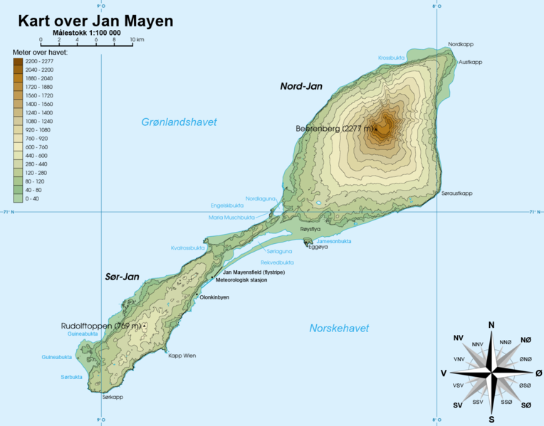
Norsk bokmål: Topografisk kart over Jan Mayen, Norge Français : Carte topographique de l'île de Jan Mayen, Norvège English: Topographic map of Jan Mayen, Norway |
||||||||
| Dato | |||||||||
| Kilde | Rémih | ||||||||
| Opphavsperson | Gryphonis | ||||||||
| Tillatelse (Gjenbruk av denne filen) |
Jeg, rettighetsinnehaver av dette arbeidet, publiserer det herved under følgende lisenser:
Du kan velge lisens etter eget valg. Denne filen er lisensiert under lisensen Creative Commons Navngivelse-DelPåSammeVilkår 1.0 Generisk
|
||||||||
| Andre versjoner | Jan Mayen topography-fr.png |

Filhistorikk
Klikk på et tidspunkt for å vise filen slik den var på det tidspunktet.
| Dato/klokkeslett | Miniatyrbilde | Dimensjoner | Bruker | Kommentar | |
|---|---|---|---|---|---|
| nåværende | 30. jan. 2011 kl. 21:54 | | 1 280 × 1 004 (384 KB) | Gryphonis | {{Information |Description={{no|Topografisk kart over Jan Mayen, Norge}}{{fr|Carte topographique de l'île de Jan Mayen, Norvège}}{{en|Topographic map of Jan Mayen, Norway}} |Source=Rémih |Date=2011-01-30 |Author=[[User:Gryphonis|Grypho |
Filbruk
De følgende 4 sidene bruker denne filen:
Global filbruk
Følgende andre wikier bruker denne filen:
- Bruk i ar.wiki.x.io
- Bruk i arz.wiki.x.io
- Bruk i ast.wiki.x.io
- Bruk i az.wiki.x.io
- Bruk i bg.wiki.x.io
- Bruk i da.wiki.x.io
- Bruk i en.wiki.x.io
- Bruk i fo.wiki.x.io
- Bruk i hy.wiki.x.io
- Bruk i id.wiki.x.io
- Bruk i is.wiki.x.io
- Bruk i ja.wiki.x.io
- Bruk i ka.wiki.x.io
- Bruk i nn.wiki.x.io
- Bruk i pt.wiki.x.io
- Bruk i ru.wiki.x.io
- Bruk i simple.wiki.x.io
- Bruk i sq.wiki.x.io
- Bruk i sv.wiki.x.io
- Bruk i uk.wiki.x.io
- Bruk i www.wikidata.org