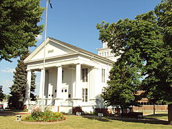
Lapeer County
fylke i Michigan i USA
Lapeer County er et fylke i den amerikanske delstaten Michigan. Det ligger på den sørlige halvøya (Lower Peninsula) og grenser mot St. Clair County i øst, Genesee County i vest, Macomb County i sørøst, Oakland County i sørvest, Sanilac County i nordøst og mot Tuscola County i nordvest.
| Lapeer County i Michigan | |||
|---|---|---|---|
 | |||
| Grunnlagt | 1835[1] | ||
| Fylkessete | Lapeer | ||
| Areal - Totalt - Land - Vann | 1 717,37 km² 1 694,37 km² 23 km² | ||
| Befolkning - Tetthet | 93 761 (2006) 54,6 innb./km² | ||
 Lapeer County 43°05′N 83°13′V | |||
Lapeer Countys totale areal er 1 717 km² hvorav 23 km² er vann. I 2000 hadde fylket 87 904 innbyggere og administrasjonssenteret ligger i byen Lapeer.
Fylket ble opprettet i 1822[2] av land fra fylkene Oakland og St. Clair County. Det har kanskje fått sitt navn etter en amerikanisering av det franske ordet le pierre (steinen) som sikter til flint. Fylket fikk fulle rettigheter 20. januar 1835.[1]
Referanser
rediger- ^ a b History of Lapeer County s. 12 Tittel: History of Lapeer County, Michigan : with illustrations and biographical sketches of some of its prominent men and pioneers
- ^ History of Lapeer County s. 11 Tittel: History of Lapeer County, Michigan : with illustrations and biographical sketches of some of its prominent men and pioneers
Eksterne lenker
rediger- (en) Offisielt nettsted
- (en) Lapeer County, Michigan – kategori av bilder, video eller lyd på Commons